|
|
|

|
10.0
°C
 50 °F
50 °F
---
Feels like:
10
24-hr difference
-8.8°C
|
|
24 HOUR TEMP TREND
|
| |
Today |
Yesterday |
| High: |
14.3°C
12:00am |
26.9°C
3:11pm |
| Low: |
9.4°C
5:36am |
14.3°C
11:40pm |
| Max Hmdx: |
15 |
|
| |
High |
Low |
| Month: |
32.8°C
on the 1st
|
9.4°C
on the 3rd |
| Year: |
35.3°C
on Jul 12th
|
-35.0°C
on Jan 25th
|
| All Time: |
41.0°C
Aug 11,2018
|
-40.8°C
Jan 28,2004 |
| |
| AirlinkData: |
Temp10.7°C
|
Humidity81%
|
| 2nd ISSData: |
Temp10.0°C
|
Humidity87%
|
| TempestData: |
Temp0°C
|
Humidity0%
|
|
|
|
Current Gust:
4.8 km/h
2 Bft -
Light Air
|
|
Gust Last Hr:
23 kmh W
|
|
Avg. Last Hr:
6.3
|
|
Gust Today:
24.1 km/h
1:46am
|
|
Gust Month: 43 km/h August 2
|
|
Tempest Wind Data
Current: 0 at 0 km/h
Gust Today: 0 km/h |
|
|
|
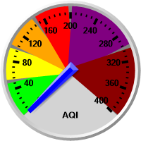
Air Quality Data
|
|
|
|
| Rain Today: |
0.0 mm
|
| Rain Today: |
0.00 in.
|
| Rain Rate (/hr): |
0.00 mm
|
| Rain Prev Hour: |
0.0 mm
|
| Rain Prev 6 Hrs: |
0.0 mm
|
| Rain Yesterday: |
0.0 mm
|
| Rain Prev Week: |
2.3 mm
|
| This Month:
x̄=46.9 |
0.0 mm
|
| Rain Month: |
0.00 in.
|
| This Year: |
271.5 mm
|
|
4 days since last rain. |
|
|
|
|
|
Today

Cloudy
Max: 17°C
Tonight

Clearing
Min: 8°C
Tue, 4 Aug

Sunny
Max: 22°C
Night

Clear
Min: 9°C
|
|